Friday 30 December 2016

30 December 2016 - Cobden Bridge, Greymouth, Westland


The old Awatere River bridge
Our last night at Lake Mahinapua was not as wonderful as I had expected, but then I prefer to camp without any companions at all, apart from my personal Cook and Chauffeur. I did not do a count however they were packing in like sardines, and I was so horrified to have large rental motorhome within touching distance of our bathroom window that I decided someone had to take charge, so out I went to move them and others still heading to the perimeter instead of making a new camp area in the centre of the camp. I was asked by fellow New Zealanders in a Trailite,  obviously annoyed to be told anything by a small Kiwi holding a bag of rubbish, if I was The Camp Commandant. I said that I had appointed myself so for the moment because I was fed up with the way everyone was being irresponsible and some order needed to be instilled. And so it was; once the first three had lined up in the middle, newcomers all followed, although there were still those travelling in cars who snuck into the gaps around the edge. It really was chaos and I was just so glad we did not have an event like that at the Lichfield Caravan Park a few nights ago when fire devastated most of the  caravans and campers. Thankfully there was no loss of life!

The next morning, we left without regret; it was time to move on. We stopped at Hokitika to fill up with diesel and refill the gas bottle that had run out on Boxing Day, then headed north again back toward Kumara Junction. We did stop on the southern bank of the Awatere River where a portion of the old Howard Truss bridge has been installed as a memorial, in the same fashion as that crossing the Waitaki River at Kurow.

This one was originally built as a rail bridge, later converted to serve road traffic as well. That was in 1891 and it served well right through to 2009 when it was replaced with a two lane road bridge and a separate rail lane. The name “Howard Truss” is named for William Howe whose design in 1840 incorporatated iron into a timber structure. He obviously knew his stuff and it would seem that his bridges, or those constructed to his design, will prove to have greater longevity than their more modern replacements.

Swingbridge over Woods Creek
Back on the road we travelled north still, past the junction and on up over the Taramakau River, that which we had followed as we descended from Arthurs Pass. Here the crossing is again on a Howard Truss bridge, or if not, a jolly good imitation, and here like the one previously across the Awatere River, a one way road and rail, crossed by first comers.

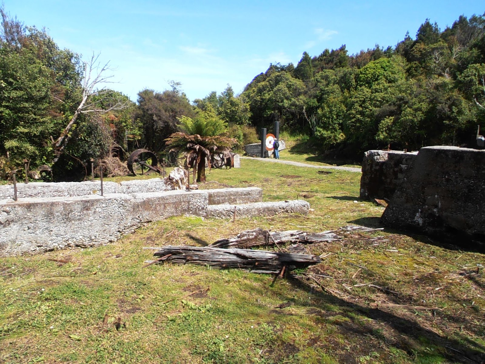
Not too far north of this, after following the coast, we turned east toward the tourist attraction Shantytown where one can experience life in a pseudo-1860 gold field settlement. We continued on up the road for another seventeen kilometres, the road now gravel but wide, no doubt to accomodate the mining traffic still working in the area although apparently not over the holiday period. We passed great swathes of upturned gravel, piles of slag but none of this explaining what kind of mining is being undertaken in these modern times. We could only guess that it was a review and reworking of the gold extraction carried out here in the 1860s.

Swingbridge exit above creek
Finally we reached a little turn around parking area, with a sign “Track” and we knew we had arrived. We had come at the suggestion of my mother who had fond memories of the walk and of staying the night in their motorhome in this relatively isolated spot. We found a flat space, one of few to be found, and then set off after lunch on this short delightful walk, which now bears the moniker “Woods Creek Walk”.  It is a mere 1.1 kilometres according to the signage but one should allow 45 minutes. Over lunch we had noted other visitors taking less time and we did ourselves when we set off, however it is very pretty and would have taken longer had we poked our heads and bodies into the tunnels that are currently ribboned off for safety purposes. 

There are tunnel entrances, tail races barely narrow enough to fit a slim hipped Asian miner and dams. The creeks are crossed with bridges, the steep slopes scaled and descended on sturdy stairs that would not have existed in the past as they do today. The path winds its way through regenerating kamihi, quintinia, rimu, kahikatea and totara; an easy path lined with soft moss, the sort of “fairy” path my sisters and I used to make through the bush behind our house when we were so very small. The last bridge is a high strung swingbridge seeming to have very little holding it attached to the opposing walls, appearing to terminate at the face of an eroded bank. But on reaching the end, one turns sharp right and climbs up through one of those narrow and deep tunnels, quite unsuitable for the well-fed matrons of today to pass through.

Our unofficial camping spot
Although a drive along dusty gravel to such a short walk, it was well worth the effort and I was glad I had listened to Mum’s suggestion. Like them so many years ago, probably before all the excellent interpretive panels were erected, we decided to stay there overnight. There were no signs forbidding the stay but nor were there any facilities at all to encourage one to do so.

While we passed the afternoon reading between listening and watching the finches, tomtits and tuis and a curious weka dart hither and thither, we noted the surprising number of tourists who had also come to walk. Obviously this obscure walk is not so obscure these days after all.

A large rental motorhome came in and parked tightly in beside us; a family of four stepped out and set off to do the walk, all good so far. But on their return they asked if we intended to stay on overnight. When we told them we were, they said they were too; it was allowed? 

Weka
We told them that since there was no signage to forbid the practice, it seemed there was no reason why they could not stay too, especially if they were fully self-contained. But we did ask that they move to another part of the parking area; this they were quite cross about saying this was the only flat spot. We indicated another area across the way and offered our spare levelling blocks. They managed to find a suitable spot without our offerings and sat out on their outdoor furniture until the sun went down tolerating the sandflies in a way we would not. This morning when we left after 9am, they were still all asleep; not so hardy after all.

In fact I suspect we were shopping in the supermarket at Greymouth before they even breakfasted, or maybe stacking and storing our purchases all away? We parked up on the northern bank of the Grey River, a spot we have stayed at on several previous occasions. The sun was shining, the morning misty rain had cleared away and we set off on foot back across the river to the town just as the Trans-Alpine train arrived from Christchurch. Tourists poured out, clogging the booking office at the station, seeking and sorting rental cars and accomodation. We picked our way around their luggage to find ourselves a street map then set off downtown to find a few bits we needed.

Coalminers memorial
Greymouth today was vibrant, all the 13,550 residents of the district catering to the crowds of visitors. Although later after the train left and the arriving passengers had been set on their way, small pockets of the catering locals sat about in groups resting, smoking and refuelling after the onslaught. We wandered along the cycleway that follows the top of the flood wall and looked across the river to our camp, up the river to the mountains and back out over the aging township. On a vacant block a young man sang to the accompaniment of a kareoke machine, busking to the absent and without success. Apparently he was more interested in listening to his own voice than targeting a viable money stream.

Greymouth and the Grey River
Greymouth has been beset with floods all through European history, the first officially recorded by explorers Heaphy and Brunner in 1846. At least two dozen floods subsequntly wrought havoc, and  the “Great Flood” of 1872 swept whole buildings out to sea, lanterns still blazing. In May 1988, the Grey River surged over its banks, engulfing the wharf area and swirling through the old town. Within four months, even before the cleanup was complete, a second and worse flood swept through, waist deep water turned the central business district into a churning sea.

The floods and mining disasters that followed were all part of West Coast life. Much more recently there were devastating floods again, in May and September 1988, and it was these two in quick succession that prompted the building of the existing flood wall in the following year. 

Part way along this wall is a wonderful memorial “In memory of those lost in coal mining incidents within the West Coast Inspection District”, unveiled by the Mayor Tony Kokshoorn in 2013 on the anniversary of the 1967 Strongman Mine disaster. More poignantly, it was unveiled on 19 November, the second anniversary of the Pike River disaster that claimed the lives of twenty nine men. (I make specific mention of the mayor by name, because he has become quite famous here in New Zealand as the spokesman for the community who today are protesting about the sealing up of the Pike River mine without having “rescued” their now long dead relatives.)

Our camp above the Grey River
Apart from the fact I found the granite sculptures of the three miners and the revolving mine portal in a base of water quite wonderful, it was the lists of names and dates of the disasters that claimed their lives that were most moving; one tends to think only of the sorrow and controversy of the most recent disaster, but the citizens of Greymouth and the district have lived with like events over and over and over again through the last one century and a half.

Back at camp, we picked up emails and caught up with other matters that rely on internet reception, something we have managed without since leaving Christchurch, sometimes because of our location and sometimes because I have preferred to spend the time with my other half.

As I write this, the sun is low in the sky and the shadows are long upon the high cliff that rises above the river. Fellow campers are out and about socialising with this one and that, but we remain tucked up out of the wind, planning our tomorrows and recording our yesterdays. 


Thursday 29 December 2016

28 December 2016 - Lake Mahinapua DOC Camp, Westland


Two days on and we have not travelled far. Yesterday morning we woke to drizzly rain and I assumed, incorrectly, that the forecasted rain had arrived early and that we would have the afternoon to do the planned walk. I also put off topping up the water tanks, sure that soon there would be a break and the exercise would be altogether more pleasant. How wrong I was!

By midday the rain was falling in great torrents and I was duty bound to fiddle about with hose and related fittings in the pouring rain. Worse still we had to attend to full effluent tanks; they would not go another day. So we drove back into Hokitika and beyond where the dump point lies adjacent to the sewerage ponds, and worked away in even heavier rain. Despite our raincoats which normally prove to be effective, we were drenched through to our underwear. We headed back to our lakeside camp, ploughing through the now ankle deep water to find another spot to park our wheels, our previous night’s posse already comandeered by another party.

The wetlands of Lake Mahinapua
Amazingly, despite the rain, the camp filled up in the late afternoon with even more parties that the night before, and few looked too happy about their camping experience. We were glad to have all our home comforts under the one roof and settled in to polish off more of the leftovers, including the last of the Christmas wine.

This morning the rain had gone, and by mid-morning the skies were clear and the sun was shining its warmth upon the bedraggled possessions of the campers, including our still soggy raincoats. We decided that it was a good morning to do that walk, the Mahinapua Walkway also known as the Mananui Tramline, a six kilometre walk from the the coastal highway through to the inland road to Rimu, at the northern end of Lake Mahinapua. Instead of walking right through to the Rimu end, we detoured to the lakeside, Picnic Point just twenty minutes from the tramway, making our return journey within two and a half hours.

Creek weed
The first part of the walk takes one down past a private farm, then across the Mahinapua Creek to the remains of the Mananui sawmill. There was once a small settlement here too, but all that remains are a few large concrete walls and bits and pieces of iron machinery. There is a large interpretative board that explains the scene and DOC keeps the grass down to an acceptable level. In fact here is the only appropriate picnic spot on the whole walkway unless there is one at the Rimu end which we did not get to.

This actual spot was first taken up by the Hokitika and Greymouth Tramway Company in 1877 so they obviously saw the potential of the wetlands as did John Maher who purchased the land eight years later. He established a flax mill, harvesting the flax from the Creek to the sea beach. Later it was all turned into a timber mill and remained so right until 1967 when Fletcher Timber Company closed its doors. Given that one tends to consider the rape of the West Coast forests as part of the 19th and early 20th centuries, it came as a surprise that this was still operating so late in the piece. In its day, the Mananui Mill processed about 90% rimu which was favoured as a building material as well as for furniture, and the remaining 10% was kahikatea, much of which was turned into cheese crates and butter boxes. 
The mill ruins
Beyond the ruins, the tramway descends to the edge of the lake, and crosses what is essentially a wetland broken by creeks. Now there is a boardwalk path through this but once there must have been a substantial bridge arrangement. Views across the lake and over this watery scene are just lovely, or at least early in the day before the sandflies and mosquitos have woken up.

Then the route follows up through regenerating native forest, the logging route cut through the sloping ground to make for the gentlest of walks. Further on the forest opens out to pines and eucalypt, surprising except for another interpretive board which removes the mystery.

Boardwalks across the wetlands
In 1921 the State Forestry Department set up experimental planting, the first trial of “exotics” planted out two years later; eight different species and 85,000 trees, mostly pines, which surely would have provided welcome employment. In 1978 much of the area was logged out, and new species planted during the 1980s, this time eucalypt and Tasmanian blackwoods. 

Plunging back into the native forest reserve, we soon came to the signed turn to Picnic Point, which appealed to Chris more than pressing on to the other road. This little track was constructed in 1937 to appeal to the tourists, and certainly the descriptive name is appealing, just half an hour return for views of the lake. But the track is uneven and entails the clambering up and down over tree roots and today was wet and muddy in many spots. It is only a route for the sure footed, wearing sturdy shoes and with at least one upper limb to  use as a balance as one clambers around to avoid the most hazardous of obstacles. Arriving at the lakeside (rather than an ellevated view point which we had expected) there is a tiny little beach and a grassy knoll that would easily accommodate a couple who are intimate with one another, because they would need to huddle tightly to keep out of the cold wind blowing across the lake. But from here you can see right across to the open space where the camp is located, and elsewhere, the “drowned” Westland Forest about the shore.
The beach at Picnic Point
Despite this negative description, we did enjoy our walk, and were ready for our late lunch when we arrived back at the carpark. We had met several cycling parties on our return, one nearly knocking us off the path. Chris remarked that the cyclist should have used his bell, but I know from experience that neither of us actually recognise the direction or sound of such devices. I suggested we have shirts or vests on with a message across the back; ”Yell to let us know you are behind us” or similar. He asked, “What?” to which I said, “Exactly!” Such deaf-eggs, the two of us!

After lunch we drove into town to get the day’s paper which incidentally had the most wonderful picture of Uluru covered in waterfalls. What a sight that would be! We decided that we may as well return to this DOC camp, as we were not wanting to travel north of Hokitika today; we had other plans for tomorrow and needed to leave from this far south. We agreed that the DOC camp, even with its motley collection of tourists and local holiday makers is far more attracive that the little NZMCA park over spot on the southern bank of the Hokitika River.


26 December 2016 - Lake Mahinapua DOC Camp, Westland


We left Weedons early on Friday morning, picked up groceries in Hornby and headed west on Highway 73. In fact the road is rarely directly west as it passes firstly through Darfield and other small settlements dotted across the expansive Canterbury Plains, changing direction as the land contours will only allow. Travelling south along the east coast one certainly gets the scale of the plains lying to the east of the Southern Alps, but this is amplified again when one heads west, expecting to arrive at the foothills sooner than reality. We had travelled this road less than two years ago when we had our tour curtailed by family bereavement, that which in turn triggered our more recent UK travels, but as I have said more than once before, a road travelled in one direction is like a differnet route travelled in the other.

View up Waimakariri River from Bealey Point
We climbed the steep road up over Porter’s Pass at 923 metres ASL and down past Lake Lyndon, past the impressive plateaus and steep sections of Castle Hill Station. I had suggested we stop and walk up about the limestone tors at Castle Hill, and although the cold drizzly conditions had not put so many other travellers off, I was pleased instead to recall the time we had done so in better weather. We pressed on through the Craigeburn area where the pines are still recovering from the terrible fires that swept through here some years ago, and pulled into the recreational area at Lake Pearson, for which our UCC Pearson motorhome is named. There we lunched and enjoyed the scenery albeit from the confines of our mobile home.

Candy's Bend on the eastern side of Arthur's Pass
Then on again, when soon the road runs alongside the Transalpine rail and the upper reaches of the Waimakariri River, still wide braided here as it is downstream. We had been surprised to see so many of the rebel Russell Lupins along this route, having belived them to be only in the Mackenzie Country. Perhaps they have spread or perhaps it was simply a matter of timing. Here as elsewhere, we were delighted to see the colour splashed about these forbidding and awesome landscapes.

It was bitterly cold at Arthur’s Pass, still drizzling from time to time, and we were not encouraged to stop and explore, although we did pull into the lookout on Deaths Corner that overlooks Candy’s Bend. While this amazing feat of road engineering is more common to the likes of Switzerland, it is rare here, and never fails to impress. The road drops so very steeply and I was quite concerned when Chris voiced his dislike of descending such sections in this motorhome of ours. I have become a bad passenger as I have become older, and I need reasurance from The Chauffeur, not shared fears. 

However, he is a very good driver, and we do have brakes, just not the wonderful exhaust brakes we had in our Canter; their throaty roar was always so reasuring as one plunged down such routes.
Soon we were travelling through the misty valleys of the Otira and Taramakau Rivers, the high peaks close about us rising into the clouds and where we had our first sight of the South Island weka for the year. One tends to think that once you are through Arthur’s Pass, you have arrived on the West Coast, but it is more than sixty kilometres from Otira to Kumara Junction, where we turned south to Hokitika, just a further twenty two kilometres on.

Looking up the Hokitika River
Hokitika, as with most of the settlements on this coast, owes its existance to the goldrush of the 1860s. These days it has a population of about 4,000, but back in its heyday, or at least within two years of gold discovery, was home to over 6,000. Conveniently situated this far down the coast, it leant itself to a direct shipping route to Melbourne which was also experiencing the same boom. Despite a particularly dangerous bar at the Hokitika River mouth, the port was briefly the country’s busiest, often with ships moored four deep along Gibson Wharf. In time, dairying and timber became the economic base for the area, although these days tourism is the mainstay. Events such as the annual mid-March  Wildfoods Festival which draw up to 20,000 and other similar fests keep interest of the town alive, and surely Eleanor Catton’s recent Man Booker prize winning novel, The Luminaries, set in mid-1860s Hokitika must be given some credit.
The Chauffeur resting on Hokitika Beach

We spent the night across the Hokitika River at the NZMCA Park, another familiar spot then moved into the Beachside Holiday Park back across on the northern edge of town the next day. It was there we spent Christmas weekend, plugged into power, making the most of long hot showers and the proximity to the beach.

On Christmas morning, after having made numerous telephone calls to family members, we wandered out on to the driftwood strewn beach and walked until we came adjacent to the commercial part of town before heading back. The beaches on this coast are wild, and although the sea was not overly wild this morning, the great tree trunks and stumps and smooth flat stones are evidence of the power so often exerted here. It is no wonder that there were shipwrecks along this coast in years gone by.

Driftwood at Hokitika

We spent the greater part of Christmas day relaxing and reading, pausing every now and again to consume food and drink we generally ration ourselves. Even today, the fridge is still bulging with icecream and other goodies that are normally verboten and there is still wine untouched. This will have to be consumed otherwise it will continue to tease us,  who have recently and temporarily removed the grape from our diet.

We drove south from Hokitika this morning, amongst the last of our fellow campers to leave but they probably had to get to Christchurch, or Te Anau, or even further afield by nightfall. Those who had spent the night here at Lake Mahinapua were not as hurried; those moving on left after we arrived. The camp is quite lovely on the shores of this typical West Coast lake, the rain forest reaching right down to the shores creating the impression of a drowned forest rather than a naturally evolved lake.
Lake Mahinapua
This lake was part of a chain of waterways that made for transport ease up and down the goldfields  and timber milling here on the coast during the mid to later 1800s. Here on the shores of Lake Mahinapua is a partially rebuilt paddle steamer , this one originally built on Gibson Quay in Hokitika in 1883; forty nine feet long and with a beam of fourteen feet. It was originally built for a contractor who was charged with dredging the Mahinapua Creek to a navigable standard.

There are several little walks accessed from the day carpark or the camp here; this afternoon we did the Bellbird walk, and did indeed hear bellbirds. But then we had been greeted by these medoius birds when we backed into our screened alcove. Blackbirds, tuis and a friendly weka, the latter whom I later fed with stale bread, had also greeted us on arrival.


Today, as over the days at the motor camp, we have had our awning out, a rarity for us who tend to remain inside looking out when not “doing stuff”. But today the cool wind drove us in early and the mosquitos kept us alert. Although I have suggested just recently that summer has arrived, I have still to shed the layers of clothing that hot weather normally forbids.