Tuesday, 10 January 2017

11 January 2017 - Karamea Domain, Buller District


If you have been reading the newspaper reports of New Zealand’s weather over the past year, you would have heard it had been warmer and dryer than many before, however there is little mention of the Buller District, or the West Coast for that matter. Here we have had so few days of clear weather, albeit sunny and warm. In fact I cannot recall dressing in anything resembling summer clothes since we arrived in the South Island in mid-December. Fortunately for us, most of the places we have been this time have been visited before, in better weather conditions, so we do know what they look like in the sunshine and how delightful summer can be down here. I just feel for those overseas people who are travelling on a time schedule and must subject themselves to rain, cold weather and poor visablity offering abbreviated views of this stunning landscape.

We left our overnight spot on the unused tennis courts at Hector after 10am, and drove north again, along the wind and rain swept coastline, a narrow strip of agricultural land dotted with nikau and cabbage trees between the wild seas and the high mountain range that runs the length of this island. Reaching the southern bank of the Mokihinui River we drove out to the river mouth to the little settlement of Mokihinui. The houses here are no more than beachside cribs although I suspect they are more permanently occupied than meets the eye; weathered fishermen were about. There is a very basic motorcamp here which most likely is well priced, however we were neither desperate to pause our journey or keen to catch fish in this isolated spot.

We continued on upriver, turning toward Seddonville in search of the car park for the Chasm Creek Walk. When we did, we found a sign advising all the bridges were closed for safety reasons. Not keen to wade creeks especially in their swollen state, we turned around and returned to Highway 67, pressing on north, crossing the long oneway bridge over the Mokihinui River and soon winding our way up over Karamea Bluff, that part of the Radiant Range covered in gloriously flowering rata and giving access to areas to the north of this rugged region. We crossed the road summit at 420 metres ASL, high in the clouds, with little visability except for the immediate road ahead. Then we came on down to Little Wanganui and hugged the coast until we reached Karamea, the largest and last commercial centre before the road comes to an end at the south western end of the famous Heaphy Track. 

The settlement boasts a population of just 575, a motorcamp, a Four Square and a general store, an excellent information centre which doubles as the farm supplies store for the area. Of course there are other facilities here, not least this simple little camping ground at the Domain where we have settled in for the afternoon and night, with mains power and internet access, all for a very modest price and hosted by the most obliging folk. How we are spoiling ourselves these days!

10 January 2017 Hector, Buller District


Here lie Denniston folk
We woke to glorious sunshine this morning, or at least enough to indicate the rains had eased. The forecast suggested this to be only a small window of good weather, perhaps only a matter of hours; we just hoped it would remain dry while we dumped, filled with water and diesel and stocked up with fresh food. We were in luck; all went smoothly and we were on the coast road north before 10.30am at first duplicating that road taken to Denniston last week.

Setting out up the Charming Creek Walkway
But at Waimangaroa, we turned toward the sea, heading for the Denniston cemetery where past residents of that spot high on the plateau left their bodily remains. Given the lack of top soil up at Denniston and the settlements about, there was no option but to bring the bodies down toward the sea where they could rest six feet under, undisturbed.

We had called in here about eight years ago, not in search of anyone in particular, simply to wander about reading the headstones and imagine the stories behind the abbreviated memorials. From down here, their ghosts could look up the incline to their last residence or out to sea from where so many of them had come by ship. The state of the stones had deteriorated in the interim, although there were a few new memorials with immigration details added to those that might have graced the originals, placed by descendants. 

The Ngakawau River
Back on the road we continued north, having passed the bygone settlements and locations of Sergeants Hill, Fairdown, Deadman’s Creek, and then Birchfield, all places part of my grandfather’s history and that of his siblings. Eight years ago we had scratched around a paddock in Birchfield looking for the remains of the Griffiths Bros Engineering workshops where my grandfather had worked as an apprentice back in the late 1800s; today everything is overgrown.

We came on through Granity, then a string of non-descript poor housing, today a little more loved and better kept, soon passing the massive coal processing and loading sheds at Ngakawai  and across the river; we took note of the old tennis courts for possible overnighting. We drove up behind Solid Energy’s works to the carpark for the Charming Creek Walkway, parked and lunched before donning our sturdy boots.

View back to the Ngakawau River mouth
The Charming Creek Railway was a privately owned line which provided transport for the timber milling and coal mining operations in the Charming Creek Valley. Brothers George and Bob Watson, sawmillers of Granity, were keen to open up the large timber resources in the area and set themselves the ambitious task of building a railway up the rugged Ngakawau Gorge. It was completed in about 1912 and ran as far as the Watson’s Mill in Charming Creek Valley.

In 1926, Bob Watson established the Charming Creek Westport Coal Company and the railway was extended. From 1929 up to six coal trains used the line daily, each way. Timber milling was small scale compared to the coal operations, which in the peak year of 1942, employed sixty nine men and produced 43,385 tonnes.

Flooding at The Bins
In 1958 the line closed, the operation no longer economic. Any remaining operations were served by a road to Seddonville, further to the north. Today it is nothing but a walking path, and cycling for the foolhardy. The whole route apparently takes three hours, but we only went half way, to the Mangatini Falls in one hour, the remains of Watson’s Mill a quarter of an hour further and then a on again for quarter of an hour, crossing three more bridges in the hope of being able to walk back to that turning point within the next couple of days, weather permitting.

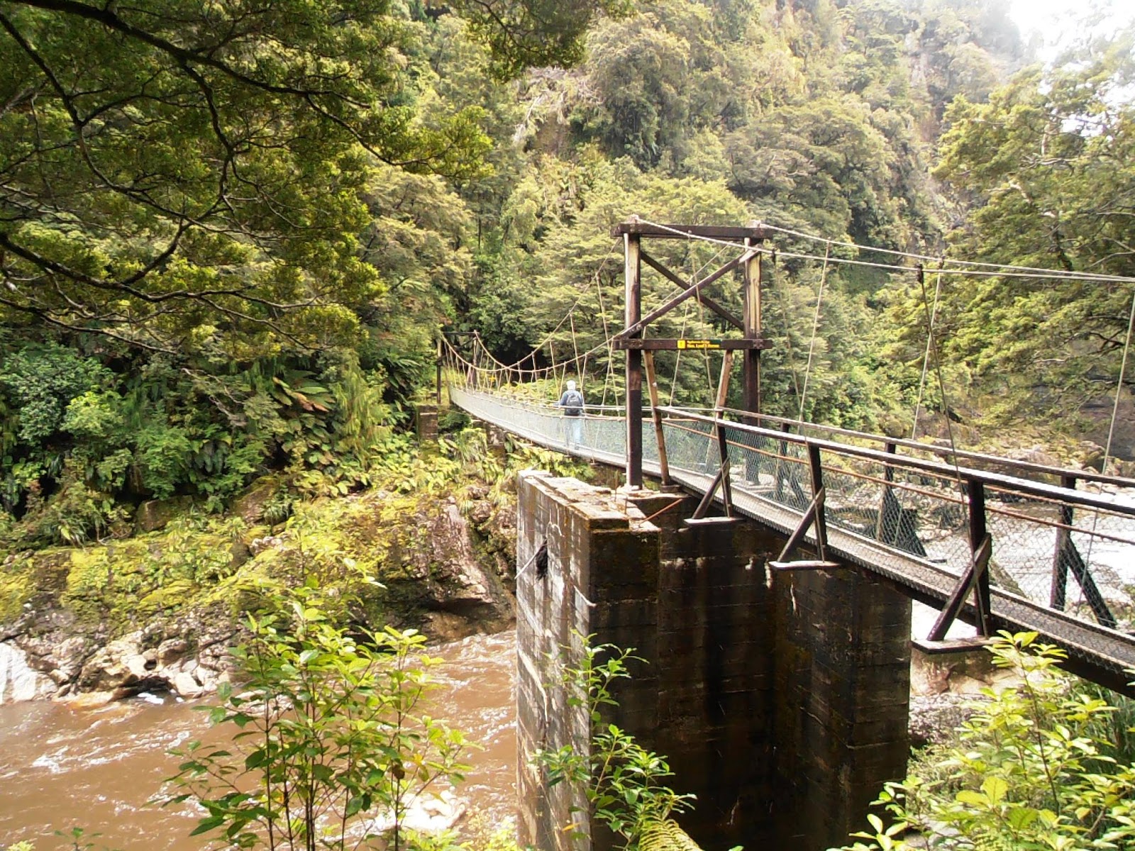
Swingbridge across the Ngakawau River
The walk is one of the most spectacular I have done, and this was probably due to the previous days’ weather. The rivers were all swollen and raging torrents, the Mangatini Falls simply magnificent as they plunged down into the Ngakawau River. The path was wet and muddy, and flooded in spots to the top of a child’s  gumboots near the open space called The Bins. Water poured from the cliffs like rain where there were no conduits; it was just marvellous and surely a unique view of what would always be a very pleasant walk.
We were delighted to encounter a robin beyond the mill, a curious little creature who would be gobbled up in no time flat is folk were allowed to bring their dogs in here. He hopped around for some time, entertaining us and no doubt interested in microscopic insects we may have stirred up with our muddy wet boots.

The Mangatini Falls down into the Ngakawau
Once back, we drove back to the tennis courts or what is left of these, between the road and the roaring sea, walked across to the run down convenience store operated by the loveliest old fellow who expressed a desire to retire sometime soon. He just needs a buyer for his store, a business which probably struggles to even supplement his pension. We bought icecreams from him and stood in the sunshine outside chatting and reminded ourselves how wise we had been to take early retirement. 
Back near our camping spot we checked out the information area, pretty well kept gardens about a rather kitsch arrangement of plaster dolphins. This is all about celebrating Hector, the place and the dolphins who are likewise named.

Old railway new Mangatini Falls
The total population of Hector’s dolphins is estimated to be about 7,400; numbers on the West Coast are about 5,400. Buller Bay supports the greatest density recorded anywhere. They were named in 1881 in honour of Sir James Hector who is probably best known for his geological survey work carried out within New Zealand. He was the first director of the Colonial Museum in Wellington.
The above statistics are gleened from the interpreative panel by the sculture and have been unchanged since at least eight years ago. Perhaps their diminishing numbers are more at crisis level now, because I do recall a news article recently decrying their demise.

This evening we are alone and likely to remain so at this hour, although there are several pukekos fossicking around in the undergrowth behind us. It seems that here one may have either pukekos or wekas, not the two together.


Sunday, 8 January 2017

9 January 2017 - South Beach NZMCA Park, Westport


Here we are back again in wet Westport, planning to stay the second night in a row, not because we are frightened to get wet but because we had problems with our 12 volt outlet plugs, and how can one exist without charging cellphones and the computer! Fortunately there was a sheet hanging in the lean-to, up above the obsolete fridge that contains the register and books for exchange, recommending the services of local “Cole”; he turned up in the rain after lunch and pulled the cabinetry apart to locate a blown fuse, reassembled everything and we were right again. However we had already paid for a further night and were not willing to forgo our whole $6! (We did worse than that in the Holianga for the sake of water.)

Connecting gold mining to Constant Bay
Yesterday morning we woke at Punakaiki to the sound of tuis surrounded by the beautiful flowering rata and eighty something other camping parties; the latter not entirely fitting with our modus operandi. Still one could not get away from the fact that the camp was in the most wonderful position and I was glad we had stayed there.

We hung about until nearly 10am, taking full advantage of the mains electricity and watching everyone head off again onto the road, most probably trying to “do”the South Island in three weeks or less. We were in no hurry as we followed suit heading north again. We stopped at the Truman Track, a very short walk from the road down to the beach through unspoiled sub-tropical forest, rimu and rata trees towering above thickets of nikau and kiekie. The track emerges on to a ledge above the wild sea, from where, when the tide is out and the sea more benign, you might walk along to a waterfall. It was raining and we remained on the flax covered ledge taking in the scene before returning. As we did so we encountered a bus load of young travellers to whom we were invisible; they obviously thought the bush path was for the young and beautiful.

Hardy beach goers at Constant Bay
About ten kilometres north, we pulled into a space near the bridge over the Fox River. There were cars and vans everywhere; the Sunday market was on. I had seen the signs the previous day advertising the event and did wonder whether we would be able to find a park, suspecting the market would be set up in the car park at the beginning of the Fox River Cave Walk. The market itself was on private property adjacent to the car park and surprisingly full of an eclectic assortment of crafts and food. None of it was crying out to be bought by us, however it was entertaining to browse and observe the people there. 

Chris on Flagstaff Hill
The car park was full, but with customers and a few folk who had braved the weather and conditions. I had suggested to Chris that we set off and see how far we could get without having to wade through riverbeds; I was not willing to subject myself to any discomfort today. We knew too that the branch to the cave was closed to walkers so it was simply a matter of following the river as far as conditions allowed. Well, we didn’t get very far. Five minutes or so in, we came upon a wide muddy expanse of water and decided to turn back. A poor effort after all!

We travelled on up the lovely coast road, winding about the cliff side, a road rated by The Lonely Planet as one of the world’s top 10 coastal drives. Arriving back at Charleston, we turned seaward to Constant Bay where we parked up for lunch and our daily constitutional. The rain had relented, or at least enough to encourage the short walk along the cliff through giant flax then on the other side of the little bay, up to Flagstaff Hill. We returned along the beach picking our way across large stones and dried bull kelp.

Constant Bay
Charleston was another nine days wonder in the story of West Coast goldmining; the “nine days” is an exaggeration. Prior to 1866 there were no Europeans here but in July of that year, payable gold was discovered and within months thouands of diggers had flocked to the goldfield. Charleston emerged on the terrace behind Constant Bay; at one time there were over eighty hotels here. At its peak Charleston had a population of about 12,000, many having come from the goldfields of Australia, Otago and Hokitika. But by late 1870 the easy pickings had dwindled and by 1875 the population had fallen to 900.  

Stones and Bull Kelp
Constant Bay was established as a port in late 1866 and soon this little bay was a hive of activity. Despite the narrow and dangerous entry, small ships up to 40 tonnes were able to enter when the sea conditions were favourable. Different coloured flags flown on Flagstaff Hill communicated whether it was safe or not to enter into the bay. It would seem that some paid no heed; there were numerous mishaps and disasters. According to the local newspaper, over two hundred vessels had used the port in its first seven months. Up to six ships were in port at any one time which we found astounding as we surveyed the bay today. By 1879 the port was closed.

Thirty kilometres further on we arrived in Westport returning to this secure little camp, where we still are as I write this. We had intended to head north today, but now that will have to wait until tomorrow.  Instead I am taking advantage of the fact that Chris has the generator running and there is internet here albeit only a couple of bars.


One of the highlights of this morning was of an avian kind; a great flock of fifty or more wood pigeons rising from the scrubby area behind us which is full of ornamental cherry trees. Many flew high up into the top of the pine tree that sits at one end of the camp, balancing precariously in the upper most tips. I have never seen more than two or three wood pigeons in flight like this; they are not at all like their cousins who habituate public squares in Europe. Unlike those we saw up in the Tararua Forest, these were far leaner. The excess rain in this region has apparently not helped the abundance of food. They continued to relocate from one spot top another all morning for no apparent reason but to provide us with entertainment.