Certainly we are
becoming soft in our old age, as was evident by complete acceptance of Chris’s
idea that we move into a powered motorcamp for New Year’s Eve. This was partly
for selfish reasons in that I knew I would have time to “play” on my computer during
the afternoon given that the forecasted storms would keep us van-bound and I
would not be able to do so, with an easy conscience or without upsetting the
Practical Captain, without mains power. Yesterday I heard him with my own ears
confess to being tight with power, so it is now official; despite the fact we
have two solar panels, a generator and, by the very fact we have lived off the
grid for several years, have become frugal in most matters, our power is
rationed to save stress and heated discussion. So with that, moving in to the
Central Campervan Park in Greymouth was a no-brainer.
The park is a small
area behind a service station, close to the centre of town, offering power,
water amd dump facilities, a laundry and a couple of unisex showers and
toilets, catering to the “low-end” of the tourist market. Most of the customers
are young folk travelling in cars or whizz-bang vans, on the cheap and
currently the butt of many letters to the newspaper editors. Personally I
dispute these nay-sayers; these folk who travel simply, not patronising the
many starred hotels and fancy restaurants, do patronise the service stations,
the supermarkets, the hardware shops and all the other kind of places they
would if they had stayed at home, as well as splashing out periodically on
meals, booze and adventure tourism. I say, give them a break, and provide
toilets and rubbish bins along their routes so they can keep our lovely land
clean and green. But then perhaps if I was a rich snob, I might say otherwise.
 Anyway, we survived
the storm through the night as one year changed to the next. The next morning
we left promptly, and headed north east up the Grey valley, the brown sludge
created by the night’s deluge soon camouflaged by the shallow gravel river braids
and lupin cover.
Anyway, we survived
the storm through the night as one year changed to the next. The next morning
we left promptly, and headed north east up the Grey valley, the brown sludge
created by the night’s deluge soon camouflaged by the shallow gravel river braids
and lupin cover.
Soon after passing
through Ikamatua which lies just north of the confluence of the Little Grey and
the Big Grey Rivers, we turned west toward Blackwater which is no more than a
cluster of houses and a long neglected school building. Here the road turns to
gravel, becomes narrow and passes up through wonderful beech forest.
 |
| Ruins on Prospect Hill |
It had surprised me to
see our destination, Waiutu, promoted in the glossy toruist brochures, because
quite frankly, who wants to meet an incompetant tourist driver on this road!
Especially when you are driving a large motorhome, or worse, if they are too!
All I can say is that I had my toes and fingers crossed all the way in and was
very very pleased when we arrived having met no-one. After the night of rain
the roadside was boggy and any place that might sometimes be consider safe,
would have been quite treacherous, but then, I did say just a few days ago, I have become a
poor passenger.
 |
| Our camping spot from the Post Office |
Waiutu was New
Zealand’s richest gold mine in its day, the last of the West Coast’s great gold
discoveries. The first big find was in 1905, and the lucky prospectors sold
their rights to a speculator for £2,000. After about £1,000 had been spent
proving the reef’s potential, it was bought for £30,000 by the London based
Consolidated Goldfields of New Zealand. By mid-1908, the Blackwater Mine, as it
was known, was fully operational and Waiutu was steadily growing around it. The
population, which peaked at over 600 in the mid-1930sm enjoyed facilities which
many larger centres went without. In 1936 when the reef had been worked well to
the north, the Company switched its operations to Prohibition shaft on a hill
above the town. It would eventually become New Zealand’s deepest mineshaft at
879 metres, more than a third of it below sea level.
In mid-1951, with enough rich quartz left to keep it going for
years, it closed abruptly. The Blackwater shaft had collapsed, letting water
and poisonous gas into the Prohibition workings. The company already struggling
with falling production, labour shortages and wage increases, decided repairs
would be uneconomic. With the closure of the mine, came the end of the town;
the citizens dispersed and the town became a ghost town except for a few hardy
souls who remained.
The mine had produced nearly three quarters of a million ounces of
gold from over one and a half million tons of quartz. From over £4,500,000 in
revenue, the company had paid nearly half a million in dividends. Of all New
Zealand mines, only the Martha at Waihi produced more during the same era.
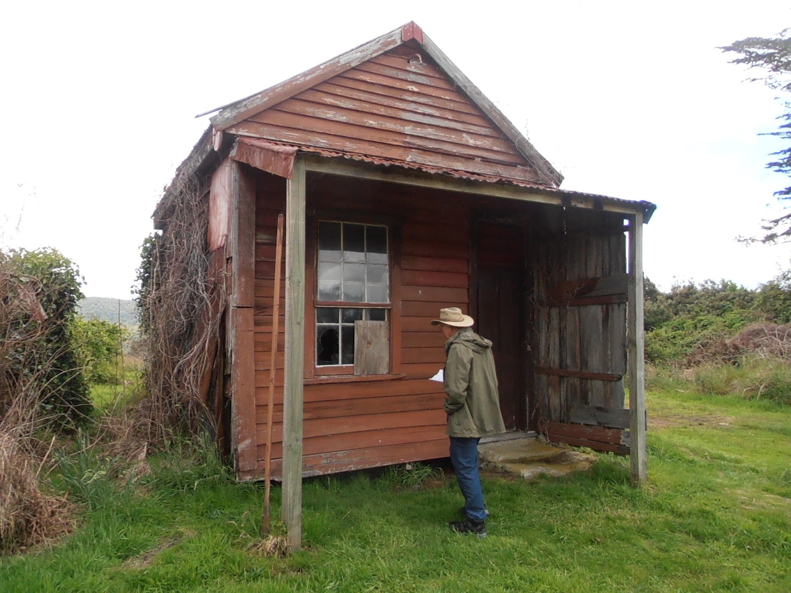
Arriving at the edge of what was once a thriving town, we headed
up to the Prohibition Shaft. We had been here almost eight years ago, and then
it had been a matter of taking great care how one went and picking about the
ruins with little signage. The Department of Conservation now has management of
the site, and with the help of the Friends of Waiutu, has done a magnificent
job in making it all tourist friendly. Massive amounts of drainage and
contouring, concreting and signage made our visit to this rather damp misty spot
up in the clouds a most interesting experience. The little road up from the
town is even narrower than that to Waiutu, so we hurried back down through the
dense beech forest before any other visitors should arrive, then settled
ourselves into a car park beside another motorhome by the ruins of the
Blackwater shaft and associated buildings.
 |
| The Barber Shop |
After lunch we walked a circuit of the town visiting the remains
of the post office, the school, the recreation area, the tennis courts,
numerous residences and shops and the swimming pools to name but a few.
Fortunately a Czech miner by the name of Joseph Divis, with an avid interest in
photography, spent some time working in the mines here, and then after being
injured, continued to document life in Waiutu, and it is many of these reproduced
photos that are the basis for the interpretative display boards about the town,
which make the whole business so much more worthwhile.
We spent the night in situ, as did the other motorhomers who had
already passed a couple before our arrival. We spent a short while chatting
with Neville and Barbara, fascinated to find that not only were they living the
gypsy life as we were but they had also spent three years travelling about
Australia, however they had done it in a motorhome, whereas we had a car and
caravan. We found too that we are heading generally in the same direction and
may well meet up during our further exploration of this part of the coast.
Both parties agreed we would be best gone as early as possible in
the morning to avoid the possibility of encountering oncoming traffic. I was
all for getting out straight after rising and breakfasting further up the road,
however Chris felt there was no such urgency and he was, of course, quite
right. We left before our fellow campers, met no one and were in Reefton,
thirty or so kilometres further north, before 9am.
Reefton with a population of little over 1,000, sits on the Inangahua
River which rises in the Victoria Range and flows on down through the most
beautiful beech forest along the road
from Springs Junction to Reefton. The town’s claim to fame includes the fact it
was the first town in New Zealand, and
one of the first in the world, to have its own electricity supply and street
lighting. During that innovative time, Reefton was the centre of numerous gold-bearing
quartz reefs, most of which were over exploited in the 1870s. It still exists
as a coal mining town and did spend many years in the doldrums, a real little
backwater, but these days Reefton is actively promoting itself for tourism.
Apart from sitting at the intersection of the roads to Greymouth, Christchurch
and Westport, a geographical position that brings tourist trade by default, it
has more recently become very popular with mountain biking.
The iStite was still to open when we arrived this morning, so we
wandered up the street buying a newspaper from the superette and several books
from a second-hand shop which has thousands of books lining the shelves in one
premises, immediately next door to a premises selling second-hand items apart
from books. The shopkeeper seemed rather overwhelmed by the number of books
hanging about and was in the throes of moving cartons outside available at $1
each. Bookworms that we are, we could of course not resist; the van is now
heavier again with volumes yet to be read.
 |
| Heading up the Murray Creek |
We parked right beside the river and read then dined accompanied by
the din of the water over the stones; it was as if an air-conditioner were
running in the van. Then we set off a couple of kilometres toward Springs Flat
to the tiny remnants of Blacks Point, the starting point for several excellent
walks in the 182,000 hectare Victoria Forest Park, most of these in the Murray
Creek Goldfield.
There are several quite long loop walks on offer, but we had been
warned by our unreliable weather app that rain was expected again at about 3pm,
so we did not wish to head away from shelter for too long. We decided to head
up Murray Creek to Energetic Junction and on to Cement Town, a distance that
took us one hour to complete. The walk climbed steadily up into the stunning
forest, following the creek on what appeared to be an old packhorse track, a
gravel-like surface buried under the confetti of beech leaves. Apart from one
small bridge cordoned off when we had to step across a stony creek, the pathway
is well maintained and is truly beautiful.
Before mining commenced in the 1880s, the steep hills were covered
in mature red and silver beech forest with an understory of fuschia, kamahi,
quintinia, five-finger jack and coprosmas. Red beech was used extensively
within the mining industry and large areas were cleared, today much of the forest
is regenerating, with red and silver beech the dominant species. We were
pleased to see so many mature trees along our route.
 |
| And crossing on the swingbridge |
Cement Town is just a couple of minutes off the loop track that
goes on to the Waitahu Junction, and was as far as we intended to walk today. We
had thought the name of the town rather odd, unimaginative, even ugly, however
did manage to make some sense of it all before too long.
Gold-bearing conglomerates, known as “cement” to the miners, were
worked over after the supply of gold nuggets ran dry. Here in 1968 a crude stamping
battery was set up for this process, and the “cement” turned up gold, copper
and even precious stones, but none in payable quantities. The associated coal
deposits eventually proved more viable.
Here in this little mound above the Murray Creek there were once a
hotel, store, bakery, slaughterhouse and market garden. Today there was little
else but the sign marking that we were in the right place and the odd scrap of
metal. It is so sad that a lively settlement can almost disappear without
trace.
Retracing our steps as far as Energetic Junction, we decided to
detour down to the Energetic Mine Shaft. Work started here in 1878, and
eventually the shaft reached a depth of 692 metres, approximately 200 metres
below sea level, at the same level those up at Prospect Hill were. Production
ceased here in 1927 due to shaft collapse, a combined output of 203,785 ounces
of gold had been achieved.
 |
| Standing in the middle of Cement Town |
Despite the “twenty minute return walk” to this shaft, we still
managed to reach the car park within two hours of setting out, that a clear indication
of the effort required on the ascent compared to the descent. We shed our heavy
boots and headed back into Reefton at once, happy the rain had yet to arrive.
We were soon set up at the racecourse, which avails itself to members of the
NZMCA for the princely sum of $2 per person per night, and still the rain had
not arrived. In fact even as I write this up tonight after 8pm, it still has
not come.